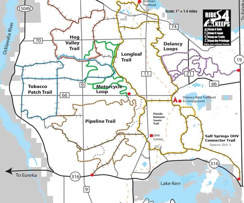
🗺 Ocala National Forest – North OHV System Overview
🔰 Main OHV Trail Systems
🟤 Hog Valley Trail
- Located west of FR 11
- Access via FR 70
- Connects toward Longleaf Trail system
- Sand-heavy, wide trail segments
🟢 Longleaf Trail
- North-central section
- Access from FR 11
- Connects to Motorcycle Loop
- Mixed pine scrub terrain
🟢 Motorcycle Loop
- Central north section
- Trailhead off FR 11
- Designated motorcycle-only singletrack
🟣 Delancy Loops
- Northeast section
- Access via FR 21
- Staging area at Delancy West Trailhead & Campground
- Tighter loop-style system
🔵 Tobacco Patch Trail
- Western section near the Ocklawaha River
- Access via FR 66
- Flatter, grid-style layout
🟤 Pipeline Trail
- South-central connector system
- Access from FR 66 and FR 11
- Connects toward OHV Center
🟡 Salt Springs OHV Connector
- Eastern/southeast extension
- Runs toward SR 19
- Connects north trails to Salt Springs area
📍 Major Trailheads & Staging Areas
🔺 Delancy West Trailhead & Campground
- Located off FR 21
- Primary access for Delancy Loops
- Campground + parking + staging
🔺 OHV Center
- Located south of Longleaf/Motorcycle area
- Access via FR 11
- Main information and staging hub
🔺 Rodman Trailhead
- Northern access point near FR 74
- Access to upper Longleaf/Hog Valley region
🛣 Major Access Roads
🟨 State Roads
- SR 19 – Major north/south east-side highway
- SR 40 – Southern boundary (Ocala access)
- SR 316 – Southern connector toward Lake Kerr
- SR 314 – West side access toward Ocala
🟨 Forest Roads (FR)
- FR 11 – Main north/south spine through trail system
- FR 21 – Access to Delancy Loops
- FR 66 – West access to Tobacco Patch & Pipeline
- FR 70 – Northwest access to Hog Valley
- FR 74 – Northern access
- FR 88 – West interior connector
- FR 50 / FR 54 – Southern grid connections
- FR 22 / FR 33 / FR 20 – Eastern forest access roads